


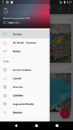


açıklaması Mobile Topographer GIS
The beloved choice of the professionals, Mobile Topographer ...meets... GIS.
You can now perform a complete survey without any limitations into complexity or volume of data.
Try now Mobile Topographer GIS by using the three days free trial period. Just download the app and proceed with he subscription procedure. Although, you will be asked to provide billing information, you will NOT be charged before the end of the three days of the free trial period. You can cancel your subscription at any time during the three days trial period, free of charge. Charges will only occur, if at the end of the three days you still have an active subscription.
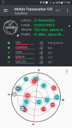
- Collect GNSS readings using increased accuracy (GPS, GLONASS, Galileo, Beidou, QZSS constellations supported).
- Connect your external GNSS receiver via mock locations and use Mobile Topogrpaher GIS as a processing unit.
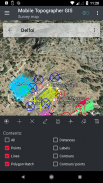
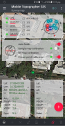
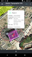
- Display data into WGS84 or you local projected CRS.
- Convert from WGS84 to local projected CRS and vice versa.
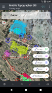
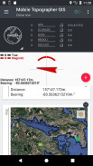
- Real time projection on map.
- *** NEW *** Custom image or WMS server as map background.
- Find a marked point in the real world by using "Drive me"
- Calculate Orthometric height on the fly using EGM model or local elevation grids where available.
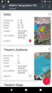
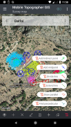
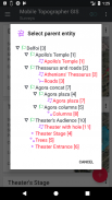
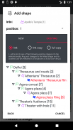
- Organize your work into Points - Shapes - Entities & Surveys. You can now create individual points, multi-point groups, multipart polylines, and multipart polygons with holes.
- Create a full drawing with as much details as you want.
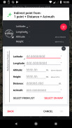
- *** NEW *** geodetic tools. Add indirect points via on of the following options: 1 point + Distance + Azimuth, 2 points + Distances + Select, 2 points + Azimuths, 3 points + Distances, Midpoint of line, Divide line, Extend line, Parallel line, Perpendicular to line.
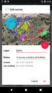
- Nest your jobs, in any nesting level, to create a super-survey.
- Share data between jobs with active links.
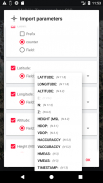
- Exchange jobs between your mobile device and your desktop computer, with import - export functions using all common formats .txt, .csv, .kml, .gpx, .dxf and Shape files (.shp - .shx - .dbf)
- Collaborate with your partners by exchanging and sharing from one point to complete jobs.
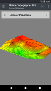
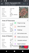
- Create the 3D terrain of an area by simply walking through it.
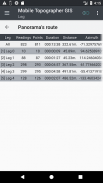
- Calculate contours and add them into your survey with lightning speeds.
- View a real 3D model directly into your device.
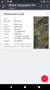
- Store a route with its data.
- Show GNSS satellites with signal info in both compass view or AR.
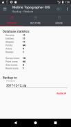
- Backup and restore your data using an SQL .db file.
Welcome to the era of mobile surveying...!
Find more about Mobile Topographer GIS in:
http://applicality.com/projects/mobile-topographer-gis/
Download the user's manual from:
http://applicality.com/app_documentation/web/MobileTopographerGIS_Manual.pdf
profesyonellerin sevgili seçim Mobil Topoğraf ... ... CBS karşılamaktadır.
Artık karmaşıklığı veya verilerin hacmi içine herhangi bir sınırlama olmadan tam bir anket gerçekleştirebilir.
Mobil Topoğraf CBS üç gün ücretsiz deneme süresi kullanılarak Şimdi deneyin. Uygulamayı indirmek ve o abonelik prosedürüne devam edin. Eğer fatura bilgileri vermeniz istenecektir, olsa da, ücretsiz deneme süresi üç gün bitmeden BORÇLANDIRILMAZSINIZ. Ücretsiz olarak, üç gün deneme süresi boyunca herhangi bir zamanda aboneliğinizi iptal edebilirsiniz. Üç gün sonunda hala aktif bir aboneliğiniz varsa Masraflar sadece, ortaya çıkar.
- Daha yüksek hassasiyet ile GNSS okumaları kazan (GPS, GLONASS, Galileo Beidou, QZSS'nin takımyıldız desteklenir).
- Sahte konumlara aracılığıyla harici GNSS alıcısı bağlayın ve bir işlem birimi olarak Mobil Topogrpaher GIS kullanın.
- WGS84 veya yerel yansıtılan CRS içine Görüntü verileri.
- WGS84 dönüştürme yerel tersi CRS öngörülen ve.
- Harita üzerinde gerçek zamanlı projeksiyon.
- *** YENİ *** Özel resim veya harita arka plan olarak WMS sunucusu.
- "Götür beni" kullanarak gerçek dünyada belirgin bir noktayı bulun
- EGM model veya yerel yükseklik ızgaralar kullanılabilir kullanılarak anında hesaplayın Ortometrik yüksekliği.
- Şekiller - - Entities & Surveys Noktalar halinde işe düzenleyin. Artık her noktayı, çok noktalı grupları, çok parçalı polylines ve delikli çok parçalı çokgenler oluşturabilirsiniz.
- İstediğiniz kadar detayları ile tam bir çizim oluşturun.
- *** YENİ *** jeodezik araçları. Aşağıdaki seçeneklerden üzerine aracılığıyla dolaylı puan ekleyin: 1 puan + Mesafe + Azimut, 2 puan + Mesafeler + Select, 2 puan + azimutlarda, 3 puan + Mesafeler, çizgi, Divide hattının Midpoint, Extend hattı, Paralel çizgi, Dik Satır .
- Nest işlerinizi, herhangi yuvalanma düzeyine, bir süper-anket oluşturun.
- Aktif bağlantıları olan işler arasında veri paylaşın.
- ithalat ile mobil cihaz ve masaüstü bilgisayarım arasında Değişim işleri - tüm ortak biçimleri kullanarak ihracat fonksiyonları .txt, .csv, .kml, .gpx, .dfx ve Şekil dosyaları (.shp - .shx - .dbf)
- alışverişi ve işleri tamamlamak için bir noktadan paylaşarak ortaklarınızla birlikte çalışın.
- basitçe içinden yürüyerek bir alanın araziyi 3D oluşturun.
- hatlarını hesaplayın ve yıldırım hızı ile Anketinizin içine ekleyin.
- Cihazınız doğrudan gerçek 3D modeli görüntüle.
- verileriyle bir rota saklayın.
- pusula görünümü veya AR hem sinyal bilgisi ile göster GNSS uyduları.
- Yedekleme ve SQL .db dosyasını kullanarak verilerinizi geri.
... mobil ölçümler çağında hoş geldiniz!
Mobil Topoğraf CBS hakkında daha fazla bulun:
http://applicality.com/projects/mobile-topographer-gis/
Kullanım kılavuzunu indirin:
http://applicality.com/app_documentation/web/MobileTopographerGIS_Manual.pdf


Mobile Topographer GIS - APK Bilgisi
APK sürümü: 6.0.15Paket: com.applicality.mobiletopographergisAynı kategorideki uygulamalar
Hoşuna gidebilecekler...


